Advertisement
Science & Tech
A ‘Hole Punch’ Cloud Makes a Rare Appearance Over Southern California
By
Margo Gothelf
1 min read
- # airplane
- # cloud
- # cloud formation
Advertisement - Continue reading below
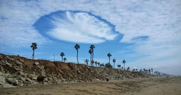
Many residents of Southern California were treated to a rare sighting of an unusual cloud formation over the weekend.
The rare cloud formation is called a “hole punch” cloud, or fallstreak hole. The infrequent shape comes from the propellers of airplanes when they pass through altocumulus cloud layers.
In order for a rare hole punch cloud to form, the clouds must be “vertically thin,” explained NBC Los Angeles.
“A plane must fly through, which creates a big temperature difference. The temperatures beneath the wings of a C-130 airplane, for example, are 14 degrees warmer than the surrounding environment,” NBC Los Angeles wrote. “This temperature difference and propeller motion creates a dry punch of air falling from the sky, evaporating the clouds beneath.”
Rare hole punch over SoCal Los Angeles area from Long Beach cloud formation wormhole? pic.twitter.com/iOyr6MB0ks
— Victor Caballero (@victorcab) January 23, 2017
According to the Weather Channel, the clouds can also take shape “when a few ice crystals ‘spontaneously’ form within the supercooled cloud and then ‘take over.’”
Many Southern California residents posted photos of the uncommon hole punch cloud formation to social media. Many users were looking to acquire some information regarding the one-of-a-kind formation.
“Hey, what kind of cloud formation is this??” one user wrote.
Check out some of the shared images below!
COOL CLOUD! Hole punch cloud seen yesterday afternoon from Los Angeles, California. Photo credit: Todd Waskow. #CAwx pic.twitter.com/8DfnIA18HB
— Mark Tarello (@mark_tarello) January 22, 2017
Advertisement - Continue reading below

